Snæfellsnes travel guide key highlights:
• Eldborg Crater
• Hraunsfjarðarvatn
• Hellnar – Arnarstapa
• Vatnshellir Cave
• Djúpalónssandur – Drítvík
• Hellissandur
• Grundarfjörður
• Berserkarhraun
• Bjarnarhöfn shark museum
• Stykkishólmur
• Flatey
 have all heard of The Golden circle and The Ring road, the road that goes around Iceland but it’s not often mentioned the drive around the Snæfellsnes peninsula. The peninsula has almost everything Iceland has to offer. You have mountain roads (three of them) which are not marked f-roads and offer easy access between the north and south side. A huge and gorgeous black sand beach where you might see big teams of horses riding along the beach, there is also quite few of excellent campsites where you can park your camper van for the night with stunning views. On the north side you have the small but beautiful Kirkjufell waterfall and of course the mountain Kirkjufell itself. There are picturesque villages dotting the northern shore and some of Iceland most fascinating fields of lava, covered with thick moss. On the most western tip, you have the vast Atlantic Ocean, wide open and brimming with whales in high season. We’ll take you along Snæfellsnes and you will be well informed before driving around the whole peninsula.
 Crossroads Hot Springs Villages Point of interest
When you drive north from Reykjavik, it’s a 69km (43miles) drive on the Ring road before you will do a left turn onto road nr:54 (Snæfellsvegur, crossroads 1) in the roundabout you come across after leaving the town of Borgarnes. It’s 69 km if you choose to drive the tunnel Hvalfjarðagöngin. You can also skip the tunnel and drive around the fjord Hvalfjörður which is beautiful. It’s only a question of time. Both routes have their charm.
Eldborg Crater

If you would drive the whole peninsula in one go, it’s about 280km (174miles). After just a few minutes after you have left the Ring road, you’ll come to historic areas and one can almost feel the battles between the different Viking clans. After you have been driving for maybe half an hour or so, you will see a sign to Snorrastaðir pointing left. From there you can take a 2,5km (1.55 miles) to get to Eldborg crater. From a distance, it almost looks like a natural fort, rising some 60 meters from the surroundings. It is also possible to walk on top of it as you can see on the pic to the left.
A few minutes further on road 54, you will see Gerðuberg basalt columns from the road on your right side. You will see a sign on your right side pointing to the right. Follow that road for around 2km and you will arrive there.
Hraunsfjarðarvatn
 When you continue west on road 54, you will soon arrive to a gas station on your right. It’s also where one can take road 56 (Vatnsvegur) to the north side through the mountains. If you do choose to cut north you will pass a lake on your left on top of that mountain pass. For those who have rented a 4×4 camper can experience a very beautiful area. After you passed the lake Baulárvallavatn, you will see a path, not looking like a real road on your left. If you drive that road, you will see another lake called Hraunsfjarðarvatn.
The water there is crystal clear, very cold and very deep and the area is just so remote for being just off the road and there is a magical feeling to the area, a sense of natural history, Vikings and mother earth. The area is very interesting to hike but it’s not for everyone. If you are into fishing, you can get a license at the gas station you passed and try to catch some very beautiful brown trout in the lake. You can also camp there but there are no facilities at all so make sure you leave the area as you found it. Leave nothing behind.
If you choose to continue west on road 54, there are many interesting places you can stop by. Replenish your water tank at Ölkelda mineral spring and keep on driving. It’s a very scenic route with so many beautiful places. Many of the roads to the left lead to the ocean and huge beaches but to reach many of them, you will often need a 4×4 camper to explore the areas freely.
If you drive road 54 all the way, it will take you over another mountain pass that is often blocked by snow during winter but is a great ride during summer. You will come to an intersection where you will see signs pointing to the left saying Hellnar and Arnarstapa, on to road 574. We suggest you take that turn and drive to those places.
Hellnar – Arnarstapa

Arnarstapi is the first of those two places you will arrive at after taking a left at crossroads 3 (see map). Arnarstapi has a great, natural harbor that is in full use. You’ll also find a campsite there and whatever you might need.
The coastline is full on ravines and lava formations. If you visit during the mating season of the tern, make sure you carry a stick above your head for they are extremely protective birds and will go for your head to make you move away but if you have the stick above you, the won’t try, they will only be intimidating.

From Arnarstapi you can walk to Hellnar, a wonderful hike among very powerful nature but you can also drive there.
By the ocean in Hellnar is a fantastic little café reminding visitor more of a Mediterranean place than an Icelandic café.
For centuries, Hellnar was the biggest fishing village and there too you’ll find the most remarkable rock formations and caves. The most famous cave there is named Baðstofa and it’s entrance can be seen from the café.
Along the rock you will also find a cold water spring dedicated to the holy virgin for she is said to have appeared there once. The water is delicious to drink too.

 Vatnshellir cave
When you continue driving west for 10 minutes or so, you will arrive at the lava tube Vatnshellir. This 8000 year old tube goes 200m into the lava and to a depth of 35m. During high season tours are offered between 10am to 6pm. You will be equipped with a helmet and flashlight for the tour.
The cave lies south of Snæfellsjökull glacier, almost right by the road you are driving and is a great opportunity to go deep into the lava…maybe it is the entrance to the center of the earth?
Djúpalónssandur – Drítvík
Driving further along, you will arrive to a sign pointing left saying Djúpalón 2. If you take that road you will come to a parking lot. Park the camper and walk on the path towards the ocean. There you will arrive at a great little beach called Djúpalónssandur. This used to be a fishing harbor but is now deserted.
 There are four very special stones on the beach where you can test your strength. The names of the stones are Fullsterkur (Full strength) weighing 154 kg, Hálfsterkur (Half strength) at 100 kg, hálfdrættingur (Weakling) at 54 kg and Amlóði (Useless) 23 kg. What’s your name? 🙂
There is a path leading north from the beach that takes you to another little beach/bay called Drítvík. When you walk there, make sure not to miss out the crazy maze you’ll find on top of the bay.
Hellissandur
 When continuing north through flat lava fields with the glacier on your right, you will come to another road to the left with the sign Öndverðarnes 579. If you take that road to the end, you will arrive at another beach, this time a yellow one. It’s called Skarðsvik and makes for a perfect stop with lunch and rest. It’s a short drive from the village Hellissandur where you will find a campsite. This side of the glacier is not frequented by many tourists so you can be sure to find peace and quiet there.
 Close by you’ll find one of Iceland’s oldest cement churches. It was built in 1903 and is a great place for some amazing shots with the glacier in the background. The views up there are amazing in all directions. You are by the foot of the glacier and to the south, the barren lava fields and to the west, the wide open North Atlantic which, during summer, offers one of the best whale watching tours in Iceland, going out from Ólafsvík.
Grundarfjörður
If you camped in Hellissandur, then Ólafsvík might be too close to camp at, or you can camp here and still explore the places above. Ólafsvík has a few incredible whale watching tours and it’s lovely to walk around in the village too. The next village after Ólafsfjörður is Grundarfjörður. The home of the wonderful mountain Kirkjufell, Iceland’s most photographed mountain.

It’s only half an hour drive between Hellissandur and Grundarfjörður so there are no distances to speak of but the nature changes for every minute you drive.
Grundarfjörður also has whale watching tours and what not. While there, you can take a ride out on the peninsula lying just east of Grundarfjörður, take a hike up the mountain and enjoy the view over Breiðafjörður, the big bay north of Snæfellsnes. The options are many.
Bjarnarhöfn shark museum
 When leaving (or staying in Grundarfjörður) you must use the opportunity to stop by Bjarnarhöfn shark museum where one of Iceland’s biggest producers of the dreaded fermented shark can be found. There is a museum there, naturally infused with the smell of the shark and you can also visit the shark “factory” too and have a bite…we dare you! 🙂
To get there, you take a left turn again by a sign saying Helgafellssveit 577 (crossroads 4). There is also a big shark made of steel on your left so you can’t miss it. After you have driven just a few minutes, there will be another sign pointing to the left, on to road 5764 and a sign saying Bjarnarhöfn.
Berserkarhraun

When you reach the shark sign, look to the right. There you have Berserkarhraun. It’s a very special field of lava. There is such a fun road to drive in between the hills of moss dressed lava hills, giving it almost an eire feeling. It’s like nothing else you have/will experience in Iceland.
The Berserkers was a family who used to hang out here, hence the name. The term “Going berserk” also originates from this family for they were known to totally loose it disputes and wars, they went berserk.
Before you reach the turn to the museum and Berserkarhraun, you will pass Hraunsfjörður, a lake with an abundance of Arctic char. If you have bought the “Fishing card”, you can fish there or just drive in there for a spot of lunch for it’s beautiful there.
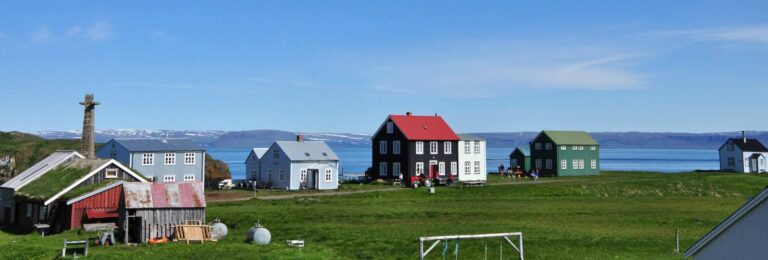
Stykkishólmur

The biggest town on Snæfellsnes is Stykkishólmur, a wonderful little town that has everything you might need. A big campsite many Icelanders also use. In the vicinity you have everything you need from horse rental, golf, swimming pools and restaurants. It’s also where the ferry across Breiðafjörður to the
Westfjords is based.
Flatey
You can take the ferry to the beautiful island of Flatey. There is one leaving every morning and after the ferry has unloaded in the Westfjords, it turns back and picks up passengers in Flatey to bring them back to Stykkishólmur. A day tour we highly recommend for you will experience Iceland in a different way, a slower, comfortable way. You should also try the food at the hotel for they pour so much love into their cocking and they also grow most of what they use on the island, including edible flowers. A treat indeed. If you are planning to drive to the Westfjords, you can also take this ferry with your camper.

Driving back to Reykjavik
When driving back or Reykjavik, you might have three choices, depending on the season You can take the main road south from there which is the mountain pass we mentioned earlier or you can continue driving east on road 55. That is another mountain pass but that road doesn’t have much maintenance and can be impassable for anything than bigger 4×4 cars so you would have to find out in advance before committing to that road. Also, be very aware if you can drive the road. By the road is a witch, frozen to stone for the sun caught her. Apparently she is not very…uhmm…kind!
The third choice is to drive road 54 (crossroads 6) all the way until you have to take a left or right turn (crossroads 7). Take a right and drive until you are on the Ring road again.
You are really spoiled for choice if you are driving around Snæfellsnes. Not only are there so many places to visit, take a load off and just let nature do its thing. Our list is far from comprehensive. There are so many other places to explore and the best part of it, you don’t have to drive all day to get between places, everything is within reach. Do you research but don’t plan every minute of the day, give plenty time for exploration, discovery outside your itinerary.
Happy Camping! #WohoCamper


Iceland Travel Guides

If you like what you see, please subscribe to our YouTube channel!
 have all heard of The Golden circle and The Ring road, the road that goes around Iceland but it’s not often mentioned the drive around the Snæfellsnes peninsula. The peninsula has almost everything Iceland has to offer. You have mountain roads (three of them) which are not marked f-roads and offer easy access between the north and south side. A huge and gorgeous black sand beach where you might see big teams of horses riding along the beach, there is also quite few of excellent campsites where you can park your camper van for the night with stunning views. On the north side you have the small but beautiful Kirkjufell waterfall and of course the mountain Kirkjufell itself. There are picturesque villages dotting the northern shore and some of Iceland most fascinating fields of lava, covered with thick moss. On the most western tip, you have the vast Atlantic Ocean, wide open and brimming with whales in high season. We’ll take you along Snæfellsnes and you will be well informed before driving around the whole peninsula.
 When you continue west on road 54, you will soon arrive to a gas station on your right. It’s also where one can take road 56 (Vatnsvegur) to the north side through the mountains. If you do choose to cut north you will pass a lake on your left on top of that mountain pass. For those who have rented a 4×4 camper can experience a very beautiful area. After you passed the lake Baulárvallavatn, you will see a path, not looking like a real road on your left. If you drive that road, you will see another lake called Hraunsfjarðarvatn.


 There are four very special stones on the beach where you can test your strength. The names of the stones are Fullsterkur (Full strength) weighing 154 kg, Hálfsterkur (Half strength) at 100 kg, hálfdrættingur (Weakling) at 54 kg and Amlóði (Useless) 23 kg. What’s your name? 🙂
 When continuing north through flat lava fields with the glacier on your right, you will come to another road to the left with the sign Öndverðarnes 579. If you take that road to the end, you will arrive at another beach, this time a yellow one. It’s called Skarðsvik and makes for a perfect stop with lunch and rest. It’s a short drive from the village Hellissandur where you will find a campsite. This side of the glacier is not frequented by many tourists so you can be sure to find peace and quiet there.
 Close by you’ll find one of Iceland’s oldest cement churches. It was built in 1903 and is a great place for some amazing shots with the glacier in the background. The views up there are amazing in all directions. You are by the foot of the glacier and to the south, the barren lava fields and to the west, the wide open North Atlantic which, during summer, offers one of the best whale watching tours in Iceland, going out from Ólafsvík.
 If you camped in Hellissandur, then Ólafsvík might be too close to camp at, or you can camp here and still explore the places above. Ólafsvík has a few incredible whale watching tours and it’s lovely to walk around in the village too. The next village after Ólafsfjörður is Grundarfjörður. The home of the wonderful mountain Kirkjufell, Iceland’s most photographed mountain.
 When leaving (or staying in Grundarfjörður) you must use the opportunity to stop by Bjarnarhöfn shark museum where one of Iceland’s biggest producers of the dreaded fermented shark can be found. There is a museum there, naturally infused with the smell of the shark and you can also visit the shark “factory” too and have a bite…we dare you! 🙂
 When you reach the shark sign, look to the right. There you have Berserkarhraun. It’s a very special field of lava. There is such a fun road to drive in between the hills of moss dressed lava hills, giving it almost an eire feeling. It’s like nothing else you have/will experience in Iceland.
 The Berserkers was a family who used to hang out here, hence the name. The term “Going berserk” also originates from this family for they were known to totally loose it disputes and wars, they went berserk.


