While the south side of Iceland has it’s very famous Golden Circle some travelers forget that the north side has its own scenic loop called the Diamond Circle. In this Diamond Circle travel guide, we’re covering both the short and extended versions of this spectacular route, along with must-see stops, local highlights, and what to expect along the way.
Getting started: Lake Mývatn
![]() Campsites
Campsites ![]() Points of interests
Points of interests ![]() Hot Springs/pools
Hot Springs/pools ![]() Crossroads
Crossroads
Follow the Diamond Circle, Iceland map for both the short and long versions of the loop. If you’re driving the full Ring Road and starting from the north, chances are you’ll be beginning your route near Lake Mývatn, so let’s start there.
There are a few campsites around Lake Mývatn and you can camp in any of them with your camper van. Depending on what route you take, the Diamond Circle is roughly 260km/162 miles long. Some parts of the road can be a bit rough but with proper speed management, it’s easy to drive any of the routes.
 There are numerous highlights around Lake Mývatn that you shouldn’t miss, including hot springs, interesting rock formations, craters and steaming hot geothermal valleys. We’ll cover those in more detail later on.
Diamond Circle, Iceland – The short version
If we start with the shorter version of the Diamond Circle in Iceland, and you decide to go counterclockwise, you’ll start by driving east on the Ring Road. From Reykjahlíð you drive east 25.8km/16 miles and make a left turn at crossroads 1 onto Road 862. This paved road and the other road east of the river (Road 864) that feeds Dettifoss and Hafragilsfoss are usually the roughest ones up here so watch out for rocks and potholes. During winter these roads close easily so make sure they are open before driving off.
Dettifoss
 After 10km/6.2 miles you will arrive at a road leading to the west parking lot for Dettifoss waterfall (crossroads 1b). Drive with care to the parking lot and follow the signs to the waterfall and enjoy the powerful nature. Dettifoss is Europe’s most powerful waterfall and has been featured in many movies, the biggest one might be Prometheus.
Here, 500 m³/s (≈17,660 ft³/s) of water pummels over the edge. An amazing amount of glacial water passes this canyon. It’s 45m/147.6ft high and 100m/328.1ft wide. One cannot be anything but amazed to see this volume of water move so violently down the canyon. The water comes from Jökulsá á fjöllum which gets its water from Vatnajökull glacier which in turn is very rich in sediments so the water often appears brown.
Hljóðaklettar
 After you have visited Dettifoss, continue north until you arrive at another side road on the right (crossroads 1c). It’s a 20km/12.4 miles drive you will find the beautiful campsite in Vesturdalur. From there you can also walk to the rock formation called Hljóðaklettar. Around this area you will see many strange rock formations. That were created when a glacier was passing over the molten lava and crater explosions some 8000 years ago. There are many enjoyable hikes in this area and the campsite will not be as crowded as around Lake Mývatn.
Ásbyrgi
When you head north once more, you will reach Crossroads 1d. Here where you can either take a left to continue on the Diamond Circle but we strongly suggest you take a right turn and continue just under 2km further down. There on your right side you will arrive at the entrance to the wonderful and amazing Ásbyrgi, one of the absolute biggest destinations in North Iceland.
 According to Norse mythology, the colossal, horseshoe-shaped canyon of Ásbyrgi, was formed by a hoof of Sleipnir, the god Odin’s eight-legged horse. Ásbyrgi is 3.5km/2.2 miles long and 1.1km/0.7 miles wide, and it’s is also the capital of the Elves in Iceland if you are into Icelandic sagas.
Inside the canyon, there are many hikes to explore. In the southern part of the canyon is a small pond called Botnstjörn. There is a flock of green-winged teals that settled there. You may also encounter ptarmigan, gyrfalcons and Arctic fox inside Ásbyrgi.
The canyon is split in two by a huge central cliff called Eyjan (“the island”). You can trek to the top from the campsite. From there you will have a lovely view over the canyon. This is a 5km/3.1 miles hike with a bit of uphill incline.
This leg of the trip joins the longer version of the eastern part of the Diamond Circle.
When you continue in on the Road 85 in a northwest direction you may want to stop by the massive beach and walk around the driftwood from Siberia. On a good day it’s absolutely beautiful to hike around there and take in the vast views in all directions.
Tjörnes peninsula
 To continue enjoying the spectacular views keep driving on the road until you come to Hringsbjarg. (25.8km/16 miles from Ásbyrgi). Keep your eyes open for the sign, since it is easy to miss it when you come from the south. (see map) Hringsbjarg is a 60m/180 ft tall cliff with an observation platform on the east side of Tjörnes peninsula. with a stunning view of the endless plains of Kelduhverfi county, which divide Tjörnes and Öxarfjörður. From April to mid-August you’ll see puffins here as this is an established nesting area for them.
The area from Hringsbjarg, around Tjörnes to the west side is almost uninhabited and offers you spectacular views over Öxarfjörður and the northeast corner of Iceland, weather permitting of course.
 When you have reached the northern tip of the peninsula and driven a few kilometers, you’ll arrive at Mánárbakki Folk Museum. The museum sits around black and white turf houses and showcases Iceland of a bygone era, focusing on the 20th century. There you’ll find an array of objects people had around them back in the day. This museum is also the site of a Northern Lights Research Centre. Further on Road 85 you will also find Tjörnestá, a small peninsula with a lighthouse. It’s a short walk there with incredible scenery.
There are roads here and there taking you closer to the ocean but we don’t know the conditions of them so if you want to explore, drive with care and enjoy the stunning views.
Húsavík
 When you start driving south on road 85, you will see more and more houses. From Mánárbakki museum to Húsavík, you have a 22km/13.7 miles drive ahead of you on a road that improves the closer you get to Húsavík, the biggest town on the Diamond Circle.
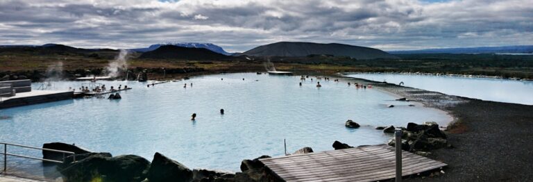
If you need to stock up on supplies, you will find everything you need in. They have an excellent swimming pool, hot springs, shopping, restaurants and not to forget, Húsavík is the whale watching capital of Iceland with plenty of different whale watching tours and companies to choose from. They also have a car museum that might be interesting for some.
Just south of Húsavík, you have a little pond (see map) called Kaldbakslaug. You can swim there, since the water is warm and, to add a bit of oddness to it, there are goldfish swimming there due to the previous owners have dumped them there.
5.5km/3.4 miles south of Kaldbakslaug you’ll come to a crossroad. It’s clearly marked with a sign saying “46 Mývatn”, pointing onto Road 87 (crossroads 3). This is where the long vs short version of the Diamond Circle splits up once more.Take a left turn here to continue doing the short Diamond Circle route.
After an 11km/6.8 miles drive, you’ll find the smallest and maybe the cutest little swimming pool called Heiðabær swimming pool. From here you have a 34.8km/21.6 miles leisurely drive back to Lake Mývatn where you have concluded the short version of the Diamond Circle. That’s a 197km/122.4 mile drive and if driven nonstop, it’s just over 3 hours.
Diamond Circle – The long version
 If we start off in Reykjahlíð once more, continue east, pass crossroads 1 and drive 36.5km/22.7 miles to your left turn (crossroads 2). The turn is well marked with signs saying “Ásbyrgi” and “Dettifoss”. It will come up very soon after you have passed the bridge over the river. Again this road, and the west side of the river too, can be a bit rough and might be closed during winter so drive with care and all will be fine. It’s a 31.1km/19.3 miles drive to the road leading to the parking lot for checking out Dettifoss waterfall from the east side (crossroads 2b).
Just over 2km/1 mile north of this crossroad, you have the neglected Hafragilsfoss Waterfall (2c). Another stunning waterfall which requires a small hike and doesn’t have a dedicated parking lot (see map). If you decide to check it out, make sure you park your camper van away from the road but remember, off-road driving is forbidden in Iceland.
Roughly 23km/14.3 miles north you’ll come to a crossroad where you have to turn, take a left turn and continue to Ásbyrgi canyon. It’s a short 4.5km/2.8 miles drive before you make a left turn.
Now you are on the same road as when you drive the shorter version. When you come to the crossroad south of Húsavík where you make a left turn for the shorter version, you continue to drive south on Road 85.
Goðafoss – The waterfall of the gods
 From Húsavík to Goðafoss waterfall is a 54km/33.6 miles drive on Road 85. When you come to the crossroad where you have to turn, make a left turn and continue 4km/2.5 miles east. Before you cross the bridge, you’ll have a road to your right leading to the main parking lot for Goðafoss but you have a choice to pass the bridge, turn right after the bridge and park your camper there and hike to the east side of Goðafoss. Here you can also buy stuff, get some food and whatnot.
 Goðafoss meaning the waterfall of the gods, got its name when the lawspeaker Þorgeir Ljósvetningagoði made Christianity the official religion of Iceland. It is said that when he returned from Alþingi, Þorgeir threw his statues of the Norse gods into the waterfall and hence the name.
Goðafoss is 12m/36 ft tall and 30m/90 ft wide. The river is fed by melting water from the glacier Vatnajökull and ends in Skjálfandi bay.
Laugar
 When you are done visiting Goðafoss, continue east, driving 10km/6.2 miles until you have to make a right turn to continue on the Ring Road. Soon after you have turned, you’ll arrive in the village of Laugar where you’ll find a great swimming pool, a campsite and a gas station. Just south of Laugar you have another wonderful little campsite, which has been spoken highly of by one of our CamperStories competitors.
 When you continue south you will arrive at the last crossroad (Road 7, see map) and your last choice for the Diamond Circle. If you take a left turn, you’ll drive north of Lake Mývatn, you will pass plenty of small craters but you will do that too when you take the south route. If you continue straight on to Road 848, you’ll pass the famous Skútustaðargígar craters. From there, it’s just a short drive until you are back to Reykjahlíð and have then concluded the longer version of the Diamond Circle. A 260km/162 miles trip which, if driven nonstop, would take you just under 4 hours.
What to do around Lake Mývatn
Around Reykjahlíð there are many impressive places to check out. The closest one is the hot spring Stóragjá. A small hot spring you have to look for and then put on your swimwear and climb down a ladder to get to it. It has crystal clear water with perfect temperatures. Check the map to find it but keep in mind you will have to look for it, since it is well hidden.
Dimmuborgir
 Dimmuborgir, meaning Dark cities or Dark castle, is an area with stunning rock formations. It lies just south of Reykjahlíð. There are paths to walk on around there so it’s an easy hike among fantastic lava formations created when a massive lava tube collapsed some 2,300 years ago. There you’ll find all sorts of small caves, lava pillars, and cells to explore. In Norse mythology it’s believed that Dimmuborgir connects to hell and in the Norwegian Christian lore they believe Satan landed there when he was thrown out from heaven. The Norwegians used to call the place “The Catacombs of Hell”.
Hverfjall Crater
 A huge crater just northeast of Dimmuborgir. There are two ways to reach the rim of the crater and you must keep to the marked paths when visiting this surreal crater. To repeat a cliche, you’ll think you are on the moon.
Hverfjall aka Hverfell is a tephra cone or tuff ring volcano and erupted some 2500 years ago. It’s a short drive south from Reykjahlíð. Just drive south a few minutes until you reach crossroads 9 (see map).
Námaskarð & Hverir Geothermal Area
 You’ll pass this area when you drive east from Reykjahlíð. And it’s a fantastic area to explore. It’s a very surreal place where you’ll have you’ll also see holes bubbling, hissing and boiling all over and the smell of sulfur lies thick in the area. When exploring the area, keep to the well-marked paths so you won’t accidentally walk into a pit and burn your foot.
If you hike up the mountain above the area, you’ll have an excellent view over the whole area and up on the mountain top, and you’ll also see strange looking pools and bursts of steam rising between rocks.
Viti Crater
 Viti crater (Viti meaning hell) was born in a very violent fashion in 1724 when magma exploded and created a 300m/1000ft wide crater and was the start of fires that lasted for 5 years. For over a hundred years Viti was nothing but a large bubbling mud pit but has now changed its character and is now a calm, green lake.
To get there you have to drive east from Reykjahlíð and take a left at crossroads 10. The road is good to drive on and you can hike around the whole crater which takes about 40 minutes. It’s a 15km/9.3-mile drive to Viti. When in the area, make sure to visit Krafla too, a geothermal plant with odd-shaped buildings.
Around Lake Mývatn
 Hike up the 524m/1719ft high mountain Vindbelgur and enjoy the tremendous view from there.
- Drive around the lake or rent a bike from Reykjahlíð and bicycle around it. It’s about 38km/23.6 miles around the lake.
- Taste the traditional Hverabrauð, a very dark bread baked in geothermal heat. Delicious with smoked Arctic Char (bleikja) or smoked lamb called Hangikjöt.
- Visit Sigurgeir’s Bird Museum.
- Enjoy a sightseeing flight from the local airport in Reykjahlíð.
- Hiking on the many trails found in the vicinity.
 Hike up the 524m/1719ft high mountain Vindbelgur and enjoy the tremendous view from there.
The Diamond Circle and the area around Lake Mývatn offer numerous has so many places to see and visit and these sites are just the most popular. If you zoom in on the map above, you’ll see more places you can visit beyond the main tourist route. The Diamond Circle & Lake Mývatn are places in North Iceland you should enjoy at your own pace, drive around at your own speed and just enjoy the stunning places you will see.
Happy exploring! #WohoCamper


Iceland Travel Guides


If you like what you see, please subscribe to our YouTube channel!