When on an Iceland trip and driving the Ring road, you will pass a few villages here and there. To be more familiar with what the different villages has to offer, what services they prove, campsite info and important numbers we put together this village guide. We will skip the villages in Snæfellsnes & the Westfjords and try to limit the guide to villages on the Ring road or very close by. Reykjavik is by far the biggest town in Iceland. Together with it’s surrounding towns they make up 2/3 of the country’s population, ballpark figure. You will find many villages here with less than 200 people which is the number required by international standard for a place to be called a village. We even have places with less than 50 people and then we have the places with the village name on both sides of the sign! (joke)
Lets start our guide in Reykjavik by driving our camper van in clockwise direction and head north
 Mosfellsbær

This village is just outside Reykjavik. Although born in Reykjavik, the Icelandic Nobel prize winning author Halldór Laxness spent most his life in Mosfellsbær and you can visit the place he lived for most of his life. There are about 10.000 people in Mosfellsbær and you’ll find most of your needs fulfilled here. Many say that the Mosfellsbær bakery is the best in the country but we’ll let other decide that! 🙂
Of course you’ll find a wonderful swimming pool to like in most villages and towns in Iceland. The campsite has everything you need and is conveniently located, more or less, in the middle of town.
Campsite GPS: 64°10’13.84″N 21°41’35.36″W
 Kjalarnes

For some reason, the next village, is considered a neighborhood in Reykjavik which makes it the biggest in area but the smallest in population. Just under 600 people live here under the roots of the mountain Esja which might also be the biggest attraction in Kjalanes for many people climb to the top every year. There are no low price food stores here but you have a gas station and a swimming pool! At times, the winds here can be astounding as can be seen in bushes and trees that grown in the common wind direction.
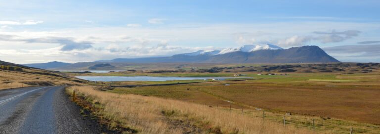
 Borgarnes

An hour away from Reykjavik, depending on if you drive under or around the fjord Hvalfjörður, you’ll arrive in Borgarnes. Just under 2000 people live here in harmony with nature. Here you will find anything you might need from banks, post office, gas stations, grocery stores, restaurants & bars. You also have an excellent campsite here. Around Borgarnes you will find a few very interesting historical sites and a golf course too.
In case of a non emergency, medical situation call 432 1430. In any emergency, call 112.
From here on, you will only pass very small villages, all the way to Akureyri in the north. But you’ll have gas stations everywhere so you are not left alone and where there is gas stations, you’ll have hot dogs too! 🙂
Campsite GPS: 64°33’5.41″N 21°54’30.59″W

Bifröst
This is a university village which has about 6 to 7 hundred students during the school year. It was founded in Reykjavik 1918 but moved to Bifröst in 1955. It lies by the roots of Mt Baula and below the lava field east of the school you have the waterfall Glanni which the 9 hole golf course in the area got its name from.
There are also many beautiful hikes in the area and a restaurant. This is the last village you’ll pass before driving over the mountain pass Holtavörðuheiði that will take you to north Iceland.

 Laugarbakki

After you have arrived in north Iceland, your first village will be Laugarbakki, one of the smallest villages you’ll see with a population of 57 people (2018 numbers). It lies above the beautiful salmon river Miðfjarðará. The village has a pool that has been converted to hot tubs. Here is also a huge ball room with room for 400 people. It is mostly used by the locals for different celebrations. There is a community center and the old boarding school has been converted to a hotel.
Campsite GPS: 65°19’36.49″N 20°53’33.11″W
 Blönduós

Blönduós is a little bit similar to Borgarnes for they have much the same things to offer, including an excellent campsite. Around the village you have many historical sites and there are a few interesting museums too. The gorgeous river Blanda runs through the village and is one of the longest rivers in Iceland.
Around Blönduós you have fantastic fishing too, both in the river and in lakes & rivers around. Inquire locally about a fishing permit.
In case of a non emergency, medical situation call 455 4100. In any emergency, call 112.
Campsite GPS: 65°39’30.24″N 20°16’37.93″W
 Varmahlíð

This little village with around 120 people is the last one before you’ll arrive in Akureyri. You have a very nice campsite there and you are in the center of horse riding in Iceland for everywhere around you, you will have stables with horses. North of the village you have one of the nicest turf farms in Iceland called Glaumbær.
Campsite GPS: 65°33’8.05″N 19°27’21.00″W
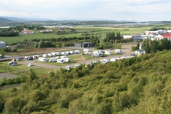
 Akureyri

The capital of north Iceland with a population close to 19.000 people. Here you’ll find all the service you might need, including a great campsite in the middle of town. They also have a wonderful music hall (pic on the right) with a full schedule all year around.
There are also whale tours from the harbor. You can also take the ferry out to Grímsey (population 61 people), Iceland’s most northern place and the only place in Iceland where you can cross the Arctic Circle.
In case of a non emergency, medical situation call 460 4600 or 463 0100. In any emergency, call 112.
Campsite GPS: 65°40’43.11″N 18° 6’2.80″W

Laugar
This wonderful village lies in the lush valley Reykjadalur (not to be confused with Reykjadalur hot springs in the south, see below under Hveragerði). The village grew up due to geothermal activities in the area. Maybe that is the reason for their gorgeous pool. There is also a gym by the pool. Despite only having just over 100 people living there, they have a restaurant, a bank, primary and secondary schools and a shop. The campsite is found in the middle of the village.
In case of a non emergency, medical situation call 464 0650. In any emergency, call 112.
Campsite GPS: N65° 43′ 22.018″ W17° 21′ 28.018″
Reykjahlíð

The beautiful little village by Lake Mývatn with just over 200 people living there. There are 3 different campsites in Reykjahlíð. The village has everything you need like a grocery store, bank, post office and a swimming pool and not to forget Mývatn nature baths, north Iceland’s answer to the Blue Lagoon. Equally good but much cheaper we are told. Many also use Reykjahlíð as their center for their explorations of the north part of Iceland. During summer, remember to bring bug spray and Mosquito net in case the Midges are out.
In case of a non emergency, medical situation call 464-0660. In any emergency, call 112.

Egilsstaðir
Technically, the next village on the Ring road and the first in East Iceland is Fellabær with just under 400 people but when you cross the bridge over Lagafljót, you are in Egisstaðir, the capital of East Iceland. Around 2500 people live here and like in any big village in Iceland, you have all the service you need.
Egilsstaðir is a perfect center for exploring Kárahnjúka up in the highlands, the more remote fjords on the east side or the old monastery Skriðuklaustur. It’s highly recommended you drive south along Lagafljót too because you will see a rare thing, namely a wonderful forest. Yes! Forest! 🙂
In case of a non emergency, medical situation call 470 3000. In any emergency, call 112.
Campsite GPS: 65°15’29.60″N 14°24’28.21″W
 Reyðarfjörður

A beautiful little village with close to 1300 people living there. It is well worth it to explore the three villages that lies all along road nr:92: Reyðarfjörður, Eskifjörður (100 people) and Neskaupsstaður (1500 people). All these three places have its charm and has something for everybody. Museums, restaurants, events and gorgeous nature.
In Reyðarfjörur they have a war museum, a pond full of fish and not to forget a hike along the river Búðará up to the waterfall.
In case of a non emergency, medical situation call 470 1420. In any emergency, call 112.
Campsite GPS: 65° 2’0.80″N 14°14’26.98″W
Fáskrúðsfjörður

When in Fáskrúðsfjörður, you will discover quite a few French street names. The reason being back in the day French fishermen used Fáskrúðsfjörður as their base and became very good friends with the locals. They even have a museum to commemorate that period. Apparently he French hospital built in 1903 is haunted. Don’t miss out on a visit to Puffin cave (during summer) while in the area.
Campsite GPS: 64°56’11.13″N 14° 2’12.90″W
 Stöðvarfjörður

Stöðvarfjörður with its 180 inhabitants have a wonderful program called “Meet the locals“. Sign up and meet the locals while you can stay in the old church which has been redone to a guesthouse.
The nature around the village is very beautiful and there are many lovely hikes in the area. In the village, there is also a stone collection that might be interesting for some.
In case of a non emergency, medical situation call 470 3088. In any emergency, call 112.
Campsite GPS: 64°49’57.63″N 13°51’40.64″W
 Breiðdalsvík

This is a very charming village with the Atlantic ocean straight outside the mouth of the harbor. The 140 people who live there takes care of t heir little pearl as can be seen in the old grocery store or the redoing of the fish factory.
Here too you can really enjoy the nature to the fullest with wonderful hikes, fishing in both a river and the sea. There is also a small forest where camping is allowed.
In case of a non emergency, medical situation call 470 3099. In any emergency, call 112.
Campsite GPS: 64°47’34.94″N 14° 0’25.65″W
Djúpivogur

A wonderful village with 350 people. The oldest house Langabúð is built in 1790 and is a central building in the village. About a kilometer away along the shore you will find a remarkable sculpture called Eggin í Gleðivík.
The nature is also fantastic here with the mountain Búlandstíndur playing a major part in the landscape. Weather permitting, take a ferry out to the island Papey with its interesting history. The campsite has everything you need within 500m from the camgrounds. Djúpivogur is also famous for its annual Hammond music festival.
In case of a non emergency, medical situation call 470 3090. In any emergency, call 112.
Campsite GPS: 64°39’20.65″N 14°17’6.03″W

Höfn

The last village on the east side or the first on the south side, however you choose to see it. The population in Höfn reaches almost 1700. Like a few other villages on the east side, the Ring road doesn’t go through the village, making these villages more quiet than others. Höfn is one of those villages. Yet again you have a campsite so well located in the middle of the village. This village is very famous for its lobsters as their lobster festival each year can testify to.
The town has everything you might need like banks, clothing stores, a supermarket and even a computer store.
In case of a non emergency, medical situation call 470 8600. In any emergency, call 112.
The longest distance between two villages on the Ring road is between Höfn and Kirkjubæjarklaustur. It’s 201 km/124.9 miles between the two villages. There is no reason for concern for you will pass at least one gas station along the way. We are not sure if the gas station by Skaftafell if it is up and running.
Campsite GPS: 64°15’29.22″N 15°12’14.94″W
Kirkjubæjarklaustur

This little village lies on the borders of the flat lava fields to the south and the mountains and highlands to the north. Stunning nature in both directions. 2018 census tells us there are 178 people living here. There are plenty of interesting hikes around this village, historical sites & natural wonders. The village has a campsite, bank, post office and a super market.
In case of a non emergency, medical situation call 432 2888. In any emergency, call 112.
Campsite GPS: 63°47’27.79″N 18° 2’59.50″W
Vík

The village that hardly needs an introduction. This village with its 400 inhabitants is probably the village in Iceland that gets its biggest share of tourism due to the black sand beach, Reynisdrangar and Dýrhólaey arch and so much more. Of course they have a great campsite too. Vík also have a good deal of interesting hikes on offer, including a AWD tour to the crashed DC-3 plane.
In case of a non emergency, medical situation call 432 2800. In any emergency, call 112.
Campsite GPS: 63°25’10.02″N 18°59’43.13″W
Hvolsvöllur

With close to a thousand people, Hvolsvöllur is one of the biggest villages on the south side. Around this area, you’ll find a lot of stables and connections to the Icelandic sagas. Hvolsvöllur is the only village in Iceland that is not developed by the sea, a river or a lake. Around the village you’ll find Njál’s saga center with information about many of the historically important events you can read about in the sagas. Hvolsvöllur is the epicenter of these events.
From here you can also travel to the famous waterfalls and not to mention, hike around Eyjafjallajökull.
Here you’ll find all the necessary services you might need like a bank, stores, a campsite and a post office.
In case of a non emergency, medical situation call 432 2700. In any emergency, call 112.
Campsite GPS: 63°44’59.22″N 20°14’19.20″W
Hella

A lovely little village on the banks of Ytri Rangá with 850 inhabitants. The village is similar to Hvolsvöllur with a bank, campsite, stores and what not. They also have a fantastic little swimming pool with two water slides. The river itself is one of the best Salmon rivers in Iceland but permits might be hard to get on site. Fishing licences are usually sold during the winter before the summer.
In case of a non emergency, medical situation call 432 2700. In any emergency, call 112.
Campsite GPS: 63°49’58.45″N 20°24’24.55″W
 Selfoss

Selfoss with its 7600 inhabitants is the biggest village in south Iceland. Here you have everything you want, even a forest on the north side and a gold course. The center has big stores, restaurants, banks and the grave of the chess master Bobby Fisher.
There are a couple campsites to choose from in and outside of the village and the local swimming pool prides both an outdoor and indoor pool.
In case of a non emergency, medical situation call 432 2000. In any emergency, call 112.
Campsite GPS: 63°56’0.25″N 20°59’18.59″W
Hveragerði

This cosy little village is the last one you pass when driving to Reykjavik clockwise around the Ring road. Hveragerði has about 2600 living there. The area is highly geothermal as can be seen when driving above the village hence it’s called the hot springs capital of the world (by the locals). It’s also here you’ll find the Reykjadalur hot spring area. It’s a 40 minute walk from Hveragerði and definitely worth it. How many times can you swim in a very warm river?
While there, make sure you get to taste some of the produce there grown in the huge green houses.
Campsite GPS: 63°59’56.17″N 21°10’54.00″W

These are the villages you will pass when you drive the Ring road. There are of course many more, not to mention the Westfjords and Snæfellsnes peninsula are not included in the Ring road trip. All farms and churches also has names too so don’t get confused with all the name signs you will encounter on your trip around Iceland.
Happy Camping! #WohoCamper


Iceland Travel Guides


If you like what you see, please subscribe to our YouTube channel!


