When driving around the Ring road in North Iceland, you will not see much if you stay on the Ring road. You will have to venture off it in your camper van and when you do, you will discover marvelous places, in fact, North Iceland offers you more opportunities to drive on roads far off the beaten path, really go places! Our North Iceland Travel guide will highlight a few of these places.
 Crossroads
  Hot Springs
  Villages
  Point of interest
If you drive straight north from Reykjavik, the first opportunity to leave the Ring road comes up 28.6 km/17.7 miles after you have passed the gas station Staðarskáli (crossroad 1, see map above). Take a left on to road:72 to Hvammstangi. The same road changes number to 711 going north from Hvammstangi.
Vatnsnes peninsula
 Hvammstangi has everything you need. A great camping site, stores, a bank, a museum, a gas station, a restaurant where you can enjoy the local cuisine to name a few things. You will also find The Icelandic Seal Center where you can find information where on the peninsula you can spot seals.
After Hvammstangi, we suggest you drive north to go around the whole peninsula. Load up with groceries and gas and take your time to enjoy this unpaved road, taking you to one of the most photographed rock formation in Iceland, namely the Rhino rock we in Iceland call Hvítserkur, an amazing rock very close to the shore. There is a restaurant north of Hvammstangi we have heard good things of so maybe it’s worth a try. If you do, please let us know what you thought in the comments below.
 Continue driving north and around the whole peninsula and enjoy the incredible views you will encounter. When you have driven south for a bit, you will reach a road to the left, taking you to the parking lot for Hvítserkur.
Park the camper and take a walk down to the ocean and enjoy.
When you are done there, continue to drive south. When you almost touch the lake Vesturhópsvatn, it’s time to take a left turn and keep on driving (2.3 km/1.4 miles) until you come to a crossroad where you have to turn left or right, take a right and continue south to the Ring road. Turn left when you reach the Ring road and head east.
Skagaströnd to Sauðárkrókur
 The route from Blöndós, going north to Skagaströnd, continuing north and ending up in Sauðárkrókur is 119.6 km/74.3 miles in total. The greater part is unpaved but it’s really worth the drive, just for the experience. Skagaströnd is a village were time is of no importance, a laid back place where you can take a load off before continuing and loading up for the trip around this peninsula. Again when driving here, take your time and enjoy the sights for they are truly stunning.
There are hardly any houses on this stretch. On the northeast side you have a lighthouse called Skagatáarviti (see map) with crazy views. You’ll find numerous interesting places to have lunch but always make sure you do not stop in the middle of the road, you never know, you might meet other cars.
Tröllaskagi
When leaving Sauðárkrókur, you don’t need to jump on the Ring road to drive on. You just continue east on road 75 and you keep on driving on that until you need to turn, turn left (north, crossroad 6)) to circle the next peninsula called Tröllaskagi.
 The first village you will arrive in is the beautiful village of Hofsós. Despite its size, it has a lot of interesting things going on like the swimming pool with a million dollar view, museum, genealogy service, exhibits and not to forget the mounds with the macabre name Mannskaðahóll which translates to Massacre hill, referring to a massacre of 80 Englishmen in 1431. According to legend, they are buried there under two mounds.
They also have a camping site there and it’s well worth it to take a load off and just enjoy the stillness and the beautiful location. The museum Vesturfarasetrið, The Icelandic Emigration Center depicts the mass emigration of Icelanders to North America in the late 1800’s.

If fishing in Iceland is on your bucket list, be sure to bring your rod and reel and fish in the numerous lakes you will pass. Just make sure you know the rules for the lake you want to fish. Some requires a license or the “Fishing card” might be enough, some might be free. Ask the locals for more information.
It’s 96 km/59.6 miles between Sauðárkrókur and Siglufjörður, the next village after Hofsós (60 km/37.2 miles). Again, take your time and enjoy the ride. Most of this road is paved but that is not a reason to rush things. When you are getting closer to Siglufjörður, the mountains get higher. The old mountain pass road that led to the village is now gone (unfortunately) and now the road is perfectly fine, paved and you’ll drive through a tunnel to get there. The municipalities of Siglufjörður and Ólafsfjörður united forces after a tunnel between them opened in 2010 and now it’s only 17 km/10.6 miles between the villages.
During summer, Siglufjörður is teeming with life. There are all kind of festivals going on, a few restaurants, galleries, art studios and all kind of activities. During winter this is a skiing & snowmobile paradise. The campsite in Siglufjörður is literally in the center of tow which makes it a perfect spot for some both for day and evening fun with the locals.
Driving to Akureyri
The drive from Siglufjörður to Akureyri where you will reconnect with the Ring road, takes you through the villages of Ólafsfjörður and Dalvík, then south along the west side of the fjord Eyjafjörður.

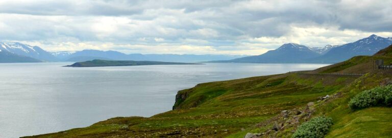
Both villages have campsites and things to do. When you come out of the one way tunnel from Ólafsfjörður, you’ll find a parking spot on your left side (the photo above is taken from there). You can stop there and enjoy the incredible view. In the photo above you can also see the island of Hrísey. An island you can visit by taking a ferry from Árskógssandur where they also have one of the more popular micro breweries in Iceland.. The ferry leaves and arrives every second hour during most days.
When the weather permits, you can see the island of Grimsey, the only place in Iceland crossed by the Arctic Circle. You can take a ferry to Grimsey from Dalvík or Akureyri (same ferry). During summer the ferry leaves 5 days a week at nine in the morning, arrives at noon and leaves from Grimsey at 5 o’clock. A fantastic trip and you get to walk over the Arctic Circle. Akureyri is Iceland’s second biggest town and there you’ll find anything you need. All these villages have whales watching tours too, including Akureyri.
Northwest Iceland
 When you continue east on the Ring road, you will reach a crossroad (Crossroad 7, see map). If you continue just a bit further, you’ll reach Goðafoss waterfall and further east, you’ll find Lake Mývatn and everything surrounding that area. Since there are so much info online for that area, we are taking the left turn at crossroad nr:7 that takes you to Húsavík.
Húsavík is called the whale capital of Iceland and it might very well be true for they have a lot of different tours to choose from and the chance of spotting whales there is pretty big. The camping site in Húsavík is slightly north of the town center and they have everything you need there.
 The drive north on road 85 around the peninsula is yet another mind blowing drive. There are not many houses there and the road is unpaved but it’s more than worth it driving this route. 60 km/37.3 miles from Húsavík, you’ll come to the turn to Ásbyrgi canyon, a must to camp and explore when you are in this area. One of the more remarkable places in Iceland according to many.
While you are camping in Ásbyrgi, you can take visit Dettifoss waterfall, Europe’s biggest waterfall. It’s a 33 km/20.5 miles drive south to get there if you choose approaching the waterfall from the east. Going to the west side is just slightly longer. both roads are a little rough and usually inaccessible during winter.
Melrakkasletta
 From Ásbyrgi the road leads north on road 85. When you reach crossroad 8, continue north to the little fishing/farming village of Kopasker, a 40 km/24.8 miles drive from Ásbyrgi. You can replenish your stocks there, fill up the camper van and you can even camp there for the night if you choose to. There is a museum there, a grocery store, gas station and camp site.
When you are done there, we highly recommend you keep on driving north on road 870. The road is unpaved and can sometimes be a little rough so just take your time. You will be far away from everything up there, one of the more desolate areas in Iceland.
This drive is simply stunning if one seeks to explore off the beaten path. The route Kopasker to Raufarhöfn, the northern route is 55.2 km/34.3 is often on rough roads which means low speed and careful driving but it is really something else. When you reach the north side of the peninsula, you will most likely see seals, driftwood from Siberia and you will just really feel you are away from everything. The northernmost lighthouse in Iceland, Hraunhafnartangi, is located there and it lies only 800 m/0.5 miles from the Arctic circle. If you want to explore it, take a left turn at crossroad 9. Drive as far as the road allows you then walk the rest. The map above isn’t as detailed and exciting as it is in real life like the screenshots below shows:


 Raufarhöfn is a small village, the most remote village in Iceland. They have basic service like a grocery store, a bank, a drugstore and of course a swimming pool worth a try. They also have a campsite in the village. When you continue to drive south, you’ll end up in another village called Þórshöfn and that concludes the 710 km/441.2 mile trip around north Iceland.
This trip only takes you on the Ring road twice and takes you to some absolutely stunning places, majestic views and some truly desolate places. One doesn’t have to drive around all the peninsulas but it’s hard to choose a favorite one since they are all unique in their own right. You also need to drive most of these roads carefully as they are not paved. If you really want to enjoy this route, allocate 4 to 5 days for this trip. It’s possible to do it in maybe 2 days but you won’t enjoy it as much.
The ones seeking road trips like this are not the ones who wants to drive like mad, stop, take pictures and move on. This is an experience to enjoy to the fullest. Sitting by a campfire with fellow travelers, exchange stories, enjoy a glass of wine under the lights of summer nights in Iceland, just “around the corner” from the Arctic circle. Any other equal experience like this will require much more driving, bear guards, total self reliance and so on. This journey only requires you to drive as the road and weather conditions allows you to. It’s not the A & B that are the goals or to quote Ralph Waldo Emerson:
“The voyage of the best ship is a zigzag line of a hundred tacks.”
Happy Camping! #WohoCamper


Iceland Travel Guides
If you like what you see, please subscribe to our YouTube channel!


